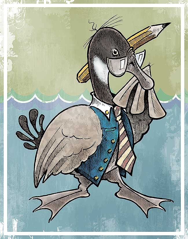
 This may well be one of the weakest links to the theme of this week's Illustration Friday, but if the shoe – or in this case, the drawing – fits, then well...post it. And just what is "fits" anyway, in these topsy-turvy modern times? I recently wrapped up this illustration as a favour to an online friend who has a brilliant idea knocking around inside his skull for a potential children's book. For anonymity's sake, I'll refer to him/her here only as Mister/Miss Ravens McOrioles – as I don't want to let the goose out of the bag before he's/she's even put pen to paper. But because the subject matter was up my alley, I offered to help flesh out a bit of imagery for the story which involves a goose and a wallaby. Side note: I've never drawn a wallaby in my life, so Mister/Miss Ravens McOrioles, we're on equal footing with that fella! The goose however, I know and know well. I was given details about the goose character in McOrioles' story idea. Goose X (not his real name) was to be an eccentric fellow, well-dressed, prone to bouts of daffiness, imagination and ideas that sometimes sink and sometimes float (hence the background scheme and loose relation to Illustration Friday's theme). I decided to give him an elderly, forgetful-professor vibe to boot; kind of a fuddy-duddy. I loosely sketched a whole manner of geese that for one reason or another didn't turn out. This fella was eventually done up in pencil last weekend, detailed in pen and coloured in Photoshop. Click here for a closer look. Do it.
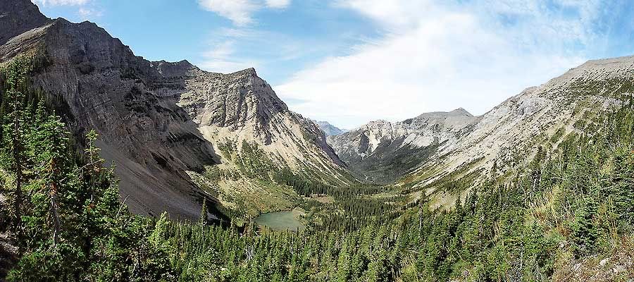
I rue the day I started taking panoramic photos. It seems now that I just can't stop. One of my favourite things to do, photography-wise, is create panoramas. It started a few years ago when vacation pics I took in Nova Scotia just didn't seem to capture the size and scope of some of the places I visited. But when I stitched a few consecutive pictures together, the effect was much improved. On the flipside, this tactic has really upped the number of film rolls I run off at any given time. Each panorama is usually constructed from anywhere between three and ten single photos, depending on the span of the subject. From there it's a seemingly endless process of colour matching and rubber-stamp work in Photoshop. 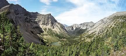
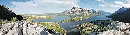
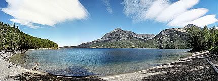
These panoramas were taken on two of the better days from my vacation. At top is the amazing view from the Bear's Hump (click here for a closer look), constructed from a series of eight separate photos. This image best shows Waterton Lakes National Park's tight transition between prairie and mountains, as well as the townsite and the park's namesake string of lakes. Above is the five-photograph, west-facing view of Crypt Valley (click here for a closer look), and below is an east-facing view along Lower Waterton Lake with some cool directional clouds (made from six photos, click here for a closer look).
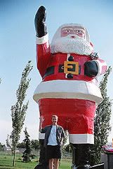
It's a nice day as we set out to Prince Albert (Saskatchewan), our first stop and a visit, long-weekend-style, with Kerry's older squister and her family. The car is loaded with snacks, a fat Saturday newspaper, a fully-laden iPod with recently acquired iTrip dealie and a tank full of the most expensive gasoline in history.It seemed that our local media couldn't get enough of bears and bear attacks in the days leading up to our departure. Which sucks, on account of us vacationing in bear country, and because of Kerry's newfound worrying-about-bears. And so, a couple hundred kilometers from home, a black bear galumps across the highway – and I think, aw jeezus.In Watson, Saskatchewan, we stop to check out the giant Santa Claus (right). Watson is the self-proclaimed Christmas Capital of Whatever, population 800. We also spot a pair of great, big home-made Michelin Men a few miles down the road in Daphne. I think Saskatchewan must be the Capital of Giant Roadside Objects.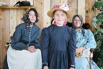
Kerry, niece Anna and older sister Jennifer sportin' vintage togs at Batôche.
In Prince Albert we have a ton of fun, starting with an awesome barbecue of beer-butt chicken. Kerry's niece Anna and nephew Duncan are a hoot and a handful. Duncan and I waste much time playing Scoot-The-Matchbox-Car-Across-The-Floor, How-Many-Times-Can-You-Hit-A-Balloon-In-The-Air (By-Using-Only-Your-Head) and Froggie-Get-In-The-Glass (don't ask, they're all complex).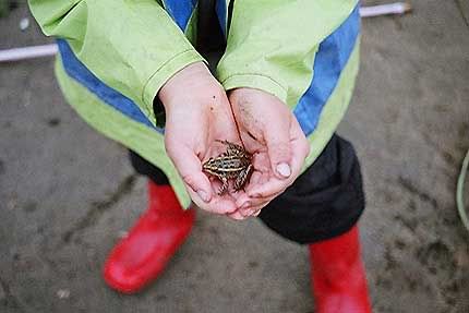
We also spend a great day touring local Canadian history hotbeds Batôche and Fort Carlton. Saskatchewan is celebrating its centennial, so cake at Fort Carlton is free and evening fireworks in Prince Albert pop to homegrown music superstars like Joni Mitchell and some group called The Tex Pistols. A rainy Labour Day is spent with Duncan and his dad Peter at a local fishing hole, where Duncan teaches me how to catch a frog (above).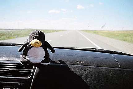
Our goes-everywhere travelmate does not appreciate the Canadian prairies.
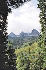
The next day's starting point Prince Albert and finishing point Waterton Lakes (Alberta) cannot be more dissimilar. Forests fade to farmland. Farms fade to tree-sparse rolling hills. Hills fade to endless miles of barren ranchland, to dry plateaus dotted with oil derricks, to foothills, to mountains. Somewhere south of Lethbridge I blink and all of the sudden they're there on the horizon. The mountains here are an amazing sight. There's almost no transition zone as they rise straight off the prairie.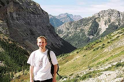
Me on the Crypt Lake Trail, a few thousand feet higher than I was a couple of hours previously.
Our first full day in Waterton may well have been the best of the entire trip. It's cloudless and hot as we pay for the boat to take us across the lake to the Crypt Landing trailhead (voted one of Canada's premier hikes). The man in line behind me sounds like Sam Elliott. "One fer th' Crypt".The Crypt Lake trail is incredible, and incredibly tough for flatlanders like us. It's an 18-kilometer, 2,300-foot ascent up a steep valley with switchbacks too numerous to count, views of four stunning waterfalls and vertigo-inducing topography. One notable segment includes rock-hopping a frigid creek, scrambling up a scree slope and a short metal ladder bolted to a cliff, then crawling through a 100-foot natural tunnel and shunting along a (cable-aided) precipitous Coyote-and-Roadrunner-esque rock wall. Looking down, though not recommended, offers views that are incredibly, incredibly cool. Reaching the end of the trail, we are rewarded with some time to kick back at Crypt Lake, which is surrounded on three sides by sheer vertical mountain faces.And then it's all done again, in reverse. Our holiday's second bear is spotted munching a safe distance from the trail.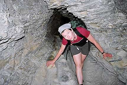
Kerry navigates the tunnel on the Crypt Lake trail.
While waiting at the trailhead dock for the boat to return, I stick my sorry-ass feet in the water. We're so sore. Back at the motel I want to fall asleep, but it’s only 8:00. We decide to at least wait until it's dark (what 29-year-old wants to admit going to bed at 8:00) and attempt to play frisbee, but my thighs are made of concrete. We swing in the swinging seat in the parking lot. Best day ever.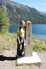
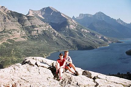
Me and Kerry atop the Bear's Hump, overlooking Lower Waterton Lake.
Until the following day. Clouds are rolling in, but it's still plenty pleasant in the morning to seek out a third nice trail that leads us to the Rowe Lakes. I can sense though, that the weather is turning – and it can, on a dime in the mountains – so we cut the hike short and decide to fill out the remainder of the day exploring the rest of the park with short stints from the car. We visit Cameron Lake, where it begins to rain lightly. It's getting colder. We take the short drive to Red Rock Canyon and Blakiston Falls when we come across a "bear-jam" (halted traffic, throng of stupid tourists, bear). And just like for rednecks when they see UFOs, my camera suddenly doesn't work.It's raining as we look around. Some guy hiking with a big cigar in his mouth asks me to take a picture of him and his wife.At night we go out on a Waterton date; out for pizza and then a movie at the little town's rickety theater. It's pitch black, wet and cold, and The Brothers Grimm is a poor choice. Some of it even creeps me out.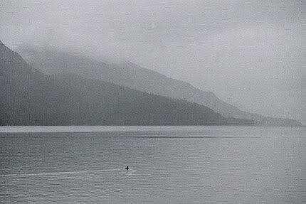
A goldeneye swims in the rain on Lower Waterton Lake.
The next few days are a total washout. It doesn't matter one day because we're doing laundry, exchanging currency and driving across the border into Montana. Funny story (though not at the time): An hour after checkout I realize we've forgotten a bottle of wine we bought in the motel room. We go back to get it, but the Hutterite cleaning women have already swigged from the bottle. And it's not even noon. Hell, we didn't even know they were allowed to drink. But the front-desk lady's hilarious head-shaking and whispered curse of "Hutterites!" will stick with me for some time.The afternoon is spent reading the fat Saturday Globe & Mail, which we wisely picked up before heading States-side. We venture outside only to the motel's cozy diner, which appropriately enough, reminds me of the restaurant chain Montana's. The day's highlight comes at 10:00, when because of our proximity to Canada, we are able to watch the fifth season premiere of The Sopranos on CTV.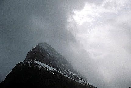
One of several bleak views offered us in Montana's Glacier National Park.
The next morning it's still raining, now sixty hours straight. To boot, it's snowed in the higher elevations. We head to the Glacier National Park visitor center to find the park's crown attraction, the Going To The Sun Highway, closed due to snow. We enter the park anyway to explore the fringe areas; the lady at the booth says "do your best". Trying out a small hike, we're caught in a deluge and we retreat to the motel to dry out. In the afternoon we're caught in another dummkopf bear-jam and scolded by the park ranger via megaphone.It's miserable cold now. That night we decide to cut short our time in the U.S. and head straight to Kerry's parents' condo in Fernie, B.C. The news reports that Fernie is suffering through an unseasonal snowstorm. But right now it's the lesser of two evils.The condo is situated in a ski resort outside of town. It's a nice place with a ping-pong table and a homey atmosphere. We stay in Fernie a few days, going for short walks when the weather's OK, heading into town and gathering our wits. The rain still shows up now and then, and felled trees from the storm impede our progress on a few local trails, but it's a cozy place in an out-of-season sort of way. On one nice day we hike into the forest (right) where the smell of gigantic cedar and fir trees is mesmerizing.We stock up at the Calgary IKEA on our long ride home. The highway from Calgary to Winnipeg is a whole lotta nuthin'. A night is spent in Swift Current, Sask. to break it into two manageable pieces. But the time goes fast, and being home is strong motivation. In the end, it was a trip full of anecdotes and funny stories. Not the two-week Rocky Mountain adventure I had hoped for, but a welcome time and a few days so memorable and nice that it was absolutely worth the crap weather we had to endure at other times. I'd do it again in an instant.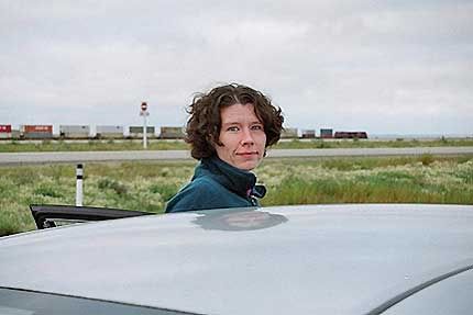
A freight train runs through Kerry's head as we switch off driving duties in Saskatchewan.
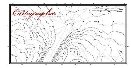
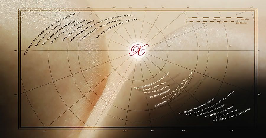
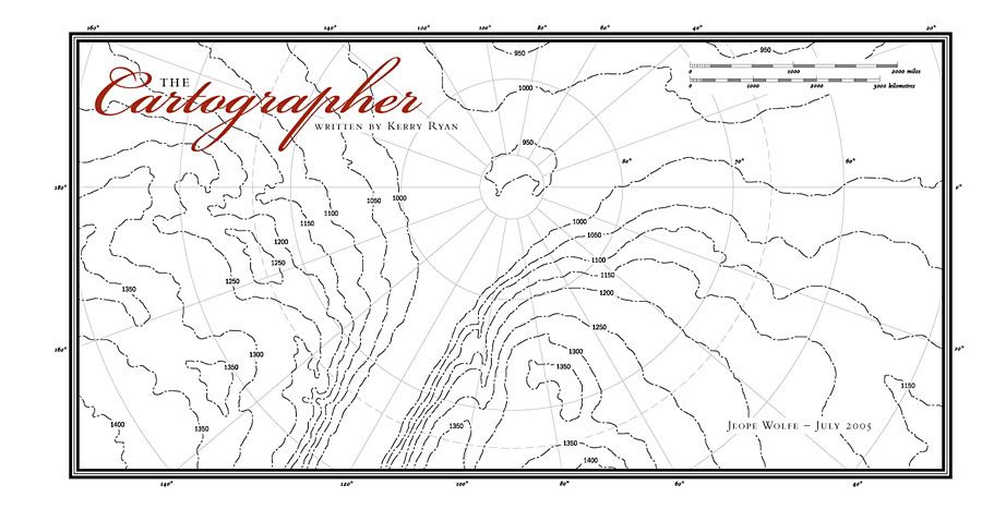
The fourth edition of the HOWieZine has been released to the extremely limited masses, so it's safe to post my submission without any protests of "spoiler!" from the dedicated designers who put time into crafting their own pages. This issue's theme was naked, a word that can conjure up an array of ideas, interpretations and imagery. As with my first submission to the HOWieZine project, I collaborated with Kerry in putting my idea to paper. The Cartographer – a poem she wrote a few years ago – became my text to play with, a beautiful story that combined nicely with my own fascination with maps.
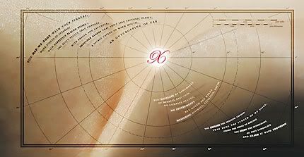 In order to accommodate the sneakily subjective photo I took (relax smut-watchdogs, they're only shoulder blades), I had to create a wider-than-normal page that eventually took on centerfold-type proportions (how apropos). The inside spread (above, click here for larger view) features Kerry's poem, split into three sections, rolling with the curves of the photo and the graticules of the map overlay. And the overlay itself is shown on the outside spread (below, click here for larger view), along with the title and lines of topography that match up with the interior photo. And of course, X always marks the spot.
